|
Northside Associated Ministries Ann Arbor, Michigan Northside Presbyterian Church/St. Aidan's Episcopal Church Adult Christian EducationAncient Land—Modern ConflictThe Historical and Political Geography of Israel and PalestineSupplement--Historical Maps of Israel and PalestineModern Israel and Palestine (1947-1990s) A large number of historical and modern maps of Israel and Palestine are available on the web. This page provides links to many of them, arranged more or less by historical period. I will be adding more maps as I come across them in the next few weeks, so check back. Because historical events and geographies are part of the contested facts in the modern conflict, users should note the source of the maps when you evaluate their "truthfulness." Contents:
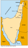
Modern Israel and Palestine (1947-1990s)
Zionist military operations outside UN-proposed Jewish state, April-May 1948 (from Palestinian Academic Society for the Study of International Affairs) Arab territories seized by Israel in 1948-49, in violation of the UN partition plan (from Palestinian Academic Society for the Study of International Affairs) Rhodes Armistice demarcation line, 1949 (from Palestinian Academic Society for the Study of International Affairs)
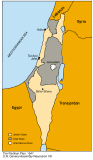
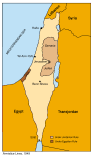
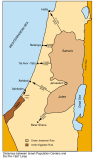
Palestine after 1967 war (from Palestinian National Authority) Golan Heights & West Bank under occupation (from Palestinian Academic Society for the Study of International Affairs) "Greater" Israel after 1967 (from Palestinian Academic Society for the Study of International Affairs) Israel-Syria demilitarized zones (from Palestinian Academic Society for the Study of International Affairs) Palestinian and Jewish land holding 1923-1999 (from Palestinian Academic Society for the Study of International Affairs) West bank and Gaza 1949-1967 , Anticipated Palestinian Autonomous Areas Year 2000 (from Palestinian Academic Society for the Study of International Affairs) Depopulated Palestinian Villages in 1948 and 1967 (from Applied Research Institute Jerusalem (Palestinian)) Names of the Depopulated Palestinian Villages in 1948 and 1967 Wars and Border Changes (1948 - 1982) (from Applied Research Institute Jerusalem (Palestinian)) West Bank and Gaza Strip Governorates and Districts According to Jordanian and Egyptian Administrations between 1948 and 1967 (from Applied Research Institute Jerusalem (Palestinian)) West Bank and Gaza Strip Districts According to Israeli Administration after 1967
This page last updated 3/10/01 |
.gif)